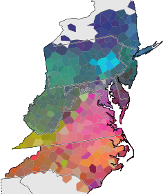
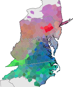
Multidimensional scalingMultidimensional scaling, or MDS, is a method to position a set of items in n-dimensional space, such that the distances in n-space correlate well with the true differences between the items.We apply MDS in three dimension, and use the resulting coordinates as colour values. X, Y, and Z are used as red, green, and blue components. The result gives a reasonable impression of the major dialect contrasts. (Image top right.) LimitationsUsing these simple red, green, and blue components (or their complements: cyan, magenta and yellow) is efficient in terms of using the full colour range of a computer monitor. However, these components do not scale in equal proportions. The green components contributes much to the contrast between light and dark, and blue contributes only little. In MDS, all axes are equally important, and rotations do not effect distances. However, swapping colour components does have a strong effect. Compare the image bottom right with the image top right. They are identical, MDS-wise.Red, green, and blue are the axes used to define colours on a computer monitor. These three axes are not what the human eye uses to discriminates between colours. The human eye sees three contrast:
To conclude: what may seem to the human eye as the most striking contrast in an MDS map not be the most striking differences as calculated by multidimensional scaling. |
|