Conflicting Personal Interests
On March 1st 1853, Congress got around to authorizing the Secretary of War to employ the Corps of Topographical Engineers to make surveys to ensure which was the "most practical and economical route for a railroad from the Mississippi River to the Pacific Ocean"[21]. The Secretary of War was Jefferson Davis, and being a Southern leader he had already decided upon a rail route between the 32nd and 35th parallels. Davis removed one obstacle to a Southern route. Surveys showed that a road with a Southern terminus would have to pass through an area in Mexican territory. So Davis sent out James Gadsden, a Southern railroad builder, to buy the region in question from Mexico. In December of 1853, Gadsden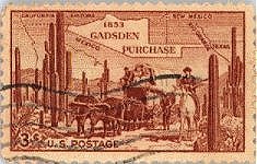 persuaded the Mexican government to sell a strip of land that today comprises part of
Arizona and New Mexico for $ 10 million, the so-called Gadsden
purchase[22]. Nevertheless,
Davis quickly dispatched engineering expeditions into the field to explore possible routes
along parallels as far north as the Canadian border. One reason for the Secretary's hurry
was that Congress had granted him only ten months to complete the surveys. This was an
almost impossible mission, considering the state of transportation at that time and the
difficulties of determining grades and finding adequate passes through the Rocky Mountains.
persuaded the Mexican government to sell a strip of land that today comprises part of
Arizona and New Mexico for $ 10 million, the so-called Gadsden
purchase[22]. Nevertheless,
Davis quickly dispatched engineering expeditions into the field to explore possible routes
along parallels as far north as the Canadian border. One reason for the Secretary's hurry
was that Congress had granted him only ten months to complete the surveys. This was an
almost impossible mission, considering the state of transportation at that time and the
difficulties of determining grades and finding adequate passes through the Rocky Mountains.
It has been said that throughout its history, the Army Corps of Engineers has had a covert and often corrupt relationship with politicians. The affair of the Pacific railway surveys was an example. Soon after the surveys began, a company that called itself the Atlantic & Pacific Railroad was founded in New York. It proposed to build a transcontinental railroad from a Southern terminus across Texas between the 32nd and 35th parallels to the village of San Diego, California. The president of the Atlantic & Pacific was one Robert J. Walker, a former senator who had been involved in land scandals, bond repudiations, and other dubious high-finance affairs in Mississippi. Jefferson Davis was deeply indebted to Walker, whose influence and sponsorship had helped the future President of the Confederacy rise to power.
Furthermore, Walker was the brother-in-law of Major William Helmsley Emory, one of the most influential officers of the Army's Topographical Engineers. He and a number of fellow officers had acquired large holdings of real estate for small sums around the village of San Diego. They would all get very rich off a transcontinental railroad with a western terminus at San Diego. Colonel John James Abert, the commander of the Corps, was so interested in the Southern route that even before the Pacific railroad surveys were authorized, he sent a Lieutenant-Colonel to Texas to find a rail route by way of El Paso to San Diego. Outside the closed circle of the Corps of Engineers were others seeking private profits. Senator Thomas Hart Benton was so determined that St. Louis (which lies between the 38th and 39th parallels) should be the terminus, and he so distrusted the Corps of Engineers, that he ordered out his own surveying party, complete with a press agent, to find a route westward along the 38th parallel. His son-in-law, John C. Fremont, soon followed with yet another survey along the 38th to ascertain that the most favorable route would end not in San Diego but in northern California, where he owned sizable quantities of land.
A former officer of the Corps of Engineers, Isaac Stevens, had his mind set on convincing the government that Asa Whitney's route between the 47th and 49th parallels was far superior to the others. Not long before the surveys were authorized, the politically inclined Stevens had given up his commission in the Engineers to become governor of Washington Territory. In this enormous, unexploited area he hoped to build his political and economic fortunes, and he needed the transcontinental railroad to make his dreams come true. Although he was now a civilian, Stevens persuaded Jefferson Davis to let him direct the military personnel of this Northern survey party.
 Stephen A. Douglas owned enough strategically located land in Chicago to become a
millionaire if his preferred route westward through Council Bluffs and Omaha was chosen. But
being a shrewd businessman, he bought up the site of a proposed terminus on Lake Superior after
learning that Isaac Stevens's survey might be shortened to that point. As for Douglas's rival,
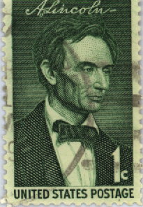
Abraham Lincoln, the future President evidently agreed
with his debating partner that the route through Council Bluffs-Omaha and South Pass was the
most practical. Lincoln acquired land interests at Council Bluffs.
Stephen A. Douglas owned enough strategically located land in Chicago to become a
millionaire if his preferred route westward through Council Bluffs and Omaha was chosen. But
being a shrewd businessman, he bought up the site of a proposed terminus on Lake Superior after
learning that Isaac Stevens's survey might be shortened to that point. As for Douglas's rival,
Abraham Lincoln, the future President evidently agreed
with his debating partner that the route through Council Bluffs-Omaha and South Pass was the
most practical. Lincoln acquired land interests at Council Bluffs.