The Surveys
As far as making it easier to select a railroad route across the West was concerned, the surveys of the Corps of Engineers accomplished nothing. As the reports were published, Southerners exaggerated the advantages of the 32nd parallel and the disadvantages of the 48th. Northern partisans did the reverse. In the volatile political situation of the 1850's neither side was willing to accept a compromise route. In a period of five years, the government spent over a million dollars in publishing the thirteen volumes of explorations and surveys for a Pacific railroad. Although they contained little information that would have helped a field surveyor in marking out a railway line, they contained an extraordinary amount of detail concerning geology, geography, land forms, American Indians, weather, trails, botanical specimens, birds, mammals, reptiles, and fish. An artist accompanied each surveying party, providing supplementary -and often colored- illustrations. Hundreds of such pictures were drawn under way. Today, these reports have no value as guides for routing the railroads, but as priceless accounts of the virgin West immediately before the Iron Horse trampled it.Surprisingly, the route along which the first transcontinental railway was eventually
built was not surveyed by any of the exploring parties of the Corps of Engineers. Its
various sections were already well known to fur traders, emigrants headed for Oregon,
and California goldseekers. It lay between the 40th and 45th parallels, a strip of land
across the continent that has always fascinated meteorologists and geographers, because
it is the track of America's 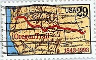 most intense climatic storms. It is worth noting that several
members of the Pacific railroad survey parties compared the routes they were surveying
with this well known South Pass route, and that they usually favored the latter, which
lies directly across the 42nd parallel.
most intense climatic storms. It is worth noting that several
members of the Pacific railroad survey parties compared the routes they were surveying
with this well known South Pass route, and that they usually favored the latter, which
lies directly across the 42nd parallel.